
A joint publication of the Allen County, Indiana
and Defiance County, Ohio Soil and Water Conservation Districts
and the Upper Maumee River Watershed Steering Committee with assistance from SNRT, Inc.
Paid for by the Indiana Dept of Environmental Management
Federal 319 Grant

UPPER MAUMEE RIVER WATERSHED MANAGEMENT PLAN
index to pg. 22
Index, Acknowledgements, Table of Contents, Table of Figures, Table of Tables, List of Acronyms, Introduction, Steering Committee Members, Stakeholder Concerns, Description of the Watershed-Acreage/County, Geology, Topology, Soils, Suitable Septic, Climate, Stream Miles
UM WMP
pg. 23-61
Hydrologic features, Scenic & Wild Rivers, Legal Drains, Wetlands, Great Black Swamp, Flooding & Levees, Flood Risk, Dams, Groundwater Resources, Water Withdrawls, Michindoh Aquifer, Land Use, Tillage Transect, Septic System Usage, Confined Feeding Operations, Windshield Survey, NPDES permits, Brownfields, Superfund Sites, CSO’s, Underground Storage Tanks, Potential Point Source Pollution Sites, Parks, Riparian Buffer Inventory, Previous Watershed Planning Efforts, Watershed Management Studies, Wellhead Protection Plans, Source Water Protection Plans, MS4, TMDL’s, Water Quality Related Social Behavior Studies
UM WMP
pg. 62-100
History of UM Watershed, Historic Sites, Demographics, Population, Workforce, Development & Building Permits, Land use for Urban Area, Adjacent Watershed Management Plans, Fort Wayne point source pollution, land use & imperviousness, Endangered Species, Invasive Species, Watershed Inventory, Stakeholder Concerns & Evidence, Watershed Inventory by Subwatershed, Water Quality Data & Parameters, Water Quality Targets & Sampling Sites, Government Integrated Reports, 303(d) List of Impaired Waters, Fish Consumption Advisories, TMDL reporting & Monitoring
Sub-Watershed Water Quality Assessment
UM WMP
pg 101-139
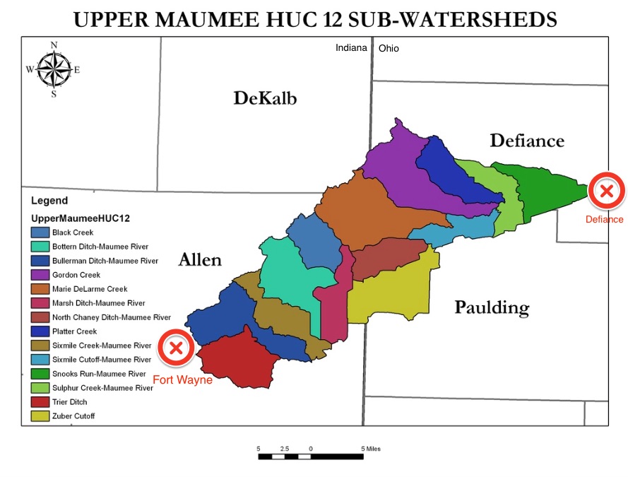
Trier Ditch
Bullerman Ditch
Sixmile Creek
Bottern Ditch
Wilbur Ditch
Grover Ditch
Black Creek
Marsh Ditch
Marie Delarme
Hamm Ditch
North Chaney Ditch
Zuber Cutoff
Viland Ditch
Gordon Creek
Sixmile Cutoff
Platter Creek
CONTINUED: Sub-Watershed Water Quality Assessment
pg.140-178
Sulphur Creek
Snooks Run
SUMMARY OF WATER QUALITY DATA
Land Use per ALL Sub-Watersheds (see pgs. 101-139)
CONTINUED: Land Use Per ALL Sub-watersheds pg.179-217
Trier Ditch
Bullerman Ditch
Sixmile Creek
Bottern Ditch
Wilbur Ditch
Grover Ditch
Black Creek
Marsh Ditch
Marie Delarme
Hamm Ditch
North Chaney Ditch
Zuber Cutoff
Viland Ditch
Gordon Creek
CONTINUED: Land Use Per ALL Sub-watersheds
pg. 218-256
Gordon Creek
Sixmile Cutoff
Platter Creek
Sulphur Creek
Snooks Run
Water Quality Concerns & Land Use Inventory Summary (MAP pg. 250)
CONTINUED: Analysis of Stakeholder Concerns
pg. 257 -295
Supported or Not Supported by Science?
Water Quality Pollution Causes, Sources & Problems
Pollution Loads & Necessary Load Reductions: DRP, E. coli
Critical Area Focus
Erosion
Land Use
Livestock
Septic
Pollutant Based
Sedimentation
Critical Area Prioritization MAPS (pg 286)
Critical Area Priority Summary (pg 289)
Goals
Indicators & Objectives
CONTINUED:
Goals, Objectives, Indicators, Measurements
pg. 296-334
Management Practices & Critical Areas (pg. 303)
General Action Register (pg. 309)
Action Register per Sub-Watershed (pg 318)
CONTINUED: Action Register per Subwatershed
pg. 335-373
Potential Annual Load Reductions After Implementation, Best Management Practices (BMP’s), non point source pollution control program, Development, Watershed Protection, On-Site Disposal, Roads, Channelization & Restoration, dams, bridges, shorelines & streambanks, future activities
References: (pg. 368)
Endorsed by: (pg. 371-373)