
Throw & Go
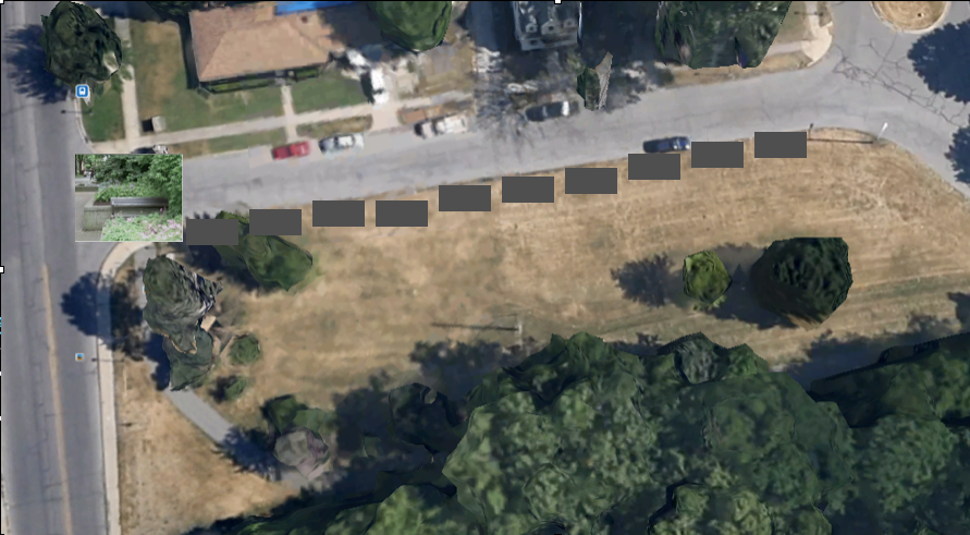
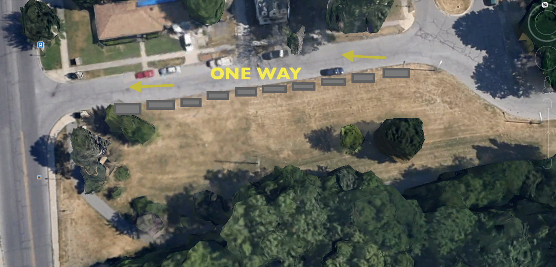
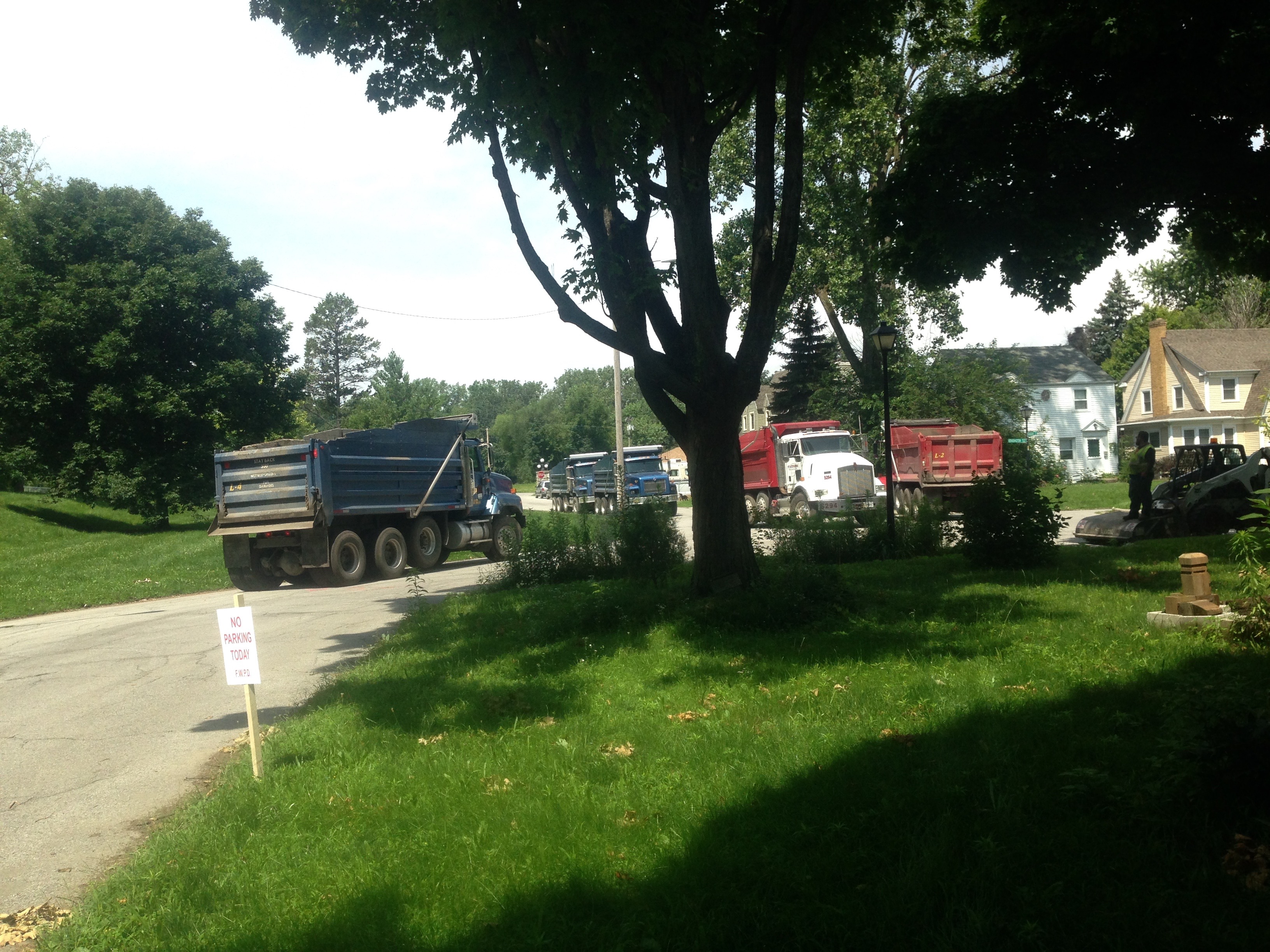
March 2016 Update: the area has been filled with gravel, to create approximately 8 more feet of space, for off street parking.
OR
July 20, 2015 Update
All the neighboring homes to this proposed redevelopment, have opposed the building of this parking lot. At this time, the neighbors who live on this street think the parking is adequate and “never have a problem finding a place to park.” The construction has begun on the east end of Niagara.
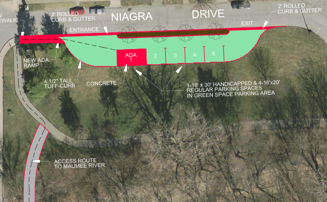
Save Maumee feels this parking lot is expensive, and redundant. It does not include best management practice of water retention, besides the over-priced impervious pavement. At this time we are unaware of any Hosey Dam portage area, upstream of the Hosey Dam, which could better serve the public. If development does not improve water quality, it should not be considered.
Please support redesigning the parking lot and reconsider this project as is. Save Maumee wants it to include proper water retention practices and increased vegetation, because of its location so close to the Maumee.
January 8, 2014 Meeting
RE: boat access on Niagara / Anthony Bridge
Pine Hill School on Beacon/Lynn 7:10PM
Shan Guartenera (Board of Public Works)
Dan Wire (Tri-State Watershed Alliance, Riverfront Dev. Allen County SWCD)
(Board of Public Works)
Patrick W. Zaharako – Assistant City Engineer
approximately 10 North Anthony Neighborhood Association Members
A. Proposal introduction to North Anthony Association:
Throw and go boat access site = ramp for canoe & kayaks
*no trailer or turnaround
SEE MAP DOCUMENT DISTRIBUTED AT MEETING – Drawing is quick concept of what COULD happen?
B. History:
What to do to make the rivers more accessible & economic driver?
- Access – throw & go model
- interest in downtown rivers lately
- Downtown rivers are economic driver for downstream as well.
- make people care by bringing them TO the water
C. Other relative Business – how this proposal came about…
- People were speaking about making accessible on Anthony due to current Anthony Bridge construction (DNR, CITY, COUNTY, PARKS DEPT)
- Currently State initiatives are interested in making rivers more accessible with their budgets (yet was explained as FEDERAL dollars being used?) Currently State initiatives are interested in making rivers more accessible with their budgets (yet was explained as FEDERAL dollars being used?) Federal grant dollars are available for States to increase access to local waterways.
- Looking for neighborhood input but was presented as a project of opportunity for NAA
D. We care what do the neighbors think?
- Will the neighborhood want it?
- DNR (Jed Pearson & Bill Seager) spoke to about access ramp off Anthony/Niagara
- MUST be handicapped accessible MUST BE – compliant with ADA
- Do NOT need gravel -greenways are made for bikes/walkers
- so instead of gravel, “hallow pavers” will allow more drainage provide hard surface for driving upon (i.e. parking lot material) Could be something like below. Images from Google search of pervious surfaces.
- provide hard surface for driving upon (i.e. parking lot material)
- will be mowed
E. Who owns property?
DNR “owns” river area – CITY owns the greenspace area on Niagara
Lease agreement between the 2 how does that money/services exchange hands?
F. Why is a parking lot needed?
Shan G. answers…
- DNR MUST provide 70X70 ft parking lot (requirements)
- American Disabilities Act MUST be fulfilled IF it’s to happen
- Army Corps of Engineers Levee will be crossed
- Permits OPEN until end of bridge project -would be easy right now
- DNR has never done a project in a neighborhood
- Access locations for better access to fire hydrants?????
- Concrete hollow paver instead of pavement/gravel
- “Greenspace” (mowed & landscape buffering)
- Landscaping requirements are involved for a parking lot area
- Federal Dollars are being spent right now
- Maumee’s high water mark will be the “end of the sidewalk.”
- Boat access MUST have ADA requirements
G. Questions posed by attendees
- What are the requirements of buffering & plants on requirements?
- Why does a vehicle need to be accessible to the water?
- Conflicting for walkers/bikers with traffic.
- Anthony vehicle traffic is heavy anyway
- Public parking is available already on-the-street, and is still quite heavy at times
- How needed is this project?
- Erosion problems from people driving on the “pavers”?
- Who would have “responsibility” of upkeep of the area?
-
Maintenance of the area? Trash?if it were a DNR boat ramp = would be open 24/7if it were a County boat ramp = would be open till dark – park hoursDNR AND/OR City Parks & Rec would maintainBathroom Facility?Lighting?
-
- NOT only for accessible to the river, but more parking?
- Grading requirements? How steep is the hill?
- ADA parking space issue with how steep the grade UP TO the north side? Grading requirements? How steep is the hill? ADA requires (approximately) no more than a 5% grade or 1” drop for 1’ of horizontal surface. A good close place to see where the DNR had installed a simple gravel boat ramp with an ADA concrete pad is on the St Joe River at Spencerville next to the covered bridge.
- ADA entry space area on the river side (south side of sidewalk) of the hill as well? Land side?
- Do we have the power to say NO to this proposal?
- Tina Kowitz from Corps said that it was OK for traffic to drive over the levee? – YES
H. SUGGESTIONS / CONCERNS
- Dwenger BLVD / Glasgow Drive would be a boat ramp area – already owned by City and goes all the way to the water….nothing to steal over there in the industrial area
- Boats & PEOPLE = increased crime
- LOTS of fishermen already – on bikes, walks & cars already don’t NEED more parking = enough public street parking
- Kids need more running play space – this will limit further
- North Anthony Association is attempting to designate this area as “historic” – this boat ramp will effect the application for designation? North Anthony Association is attempting to designate this area as “historic” – this boat ramp will effect the application for designation? From Don Orban – The current National Register nomination goes from Vance to Vermont………….so this area would not be included in the North Anthony Neighborhood nomination that is currently underway.
- This project was also thought to use as a maintenance area for equipment to access the log jams on the Hosey Dam. – but the dam is on the other side of North Anthony? This project was also thought to use as a maintenance area for equipment to access the log jams on the Hosey Dam. – but the dam is on the other side of North Anthony? The “maintenance area” would be for the County to remove logs from the piers of Anthony Blvd. Bridge. The City is responsible for the Hosey Dam.
I. Benefits to our neighborhood
- river access
- enhance the greenway trail system & experience
- thriving communities have access to navigable streams for recreation
- development does not have to mean brick and mortar
- “grow” our rivers & community
J. Outcomes –
DECISION TO BE REACHED AT NAA MEETING, Monday Jan 27th
- Definitely NO on the parking lot
- President Mike requesting research, discussion & thought until next meeting in approx. 2 weeks where vote will be officially taken
Respectfully Submitted by Abigail King, NAA Member, Save Maumee Grassroots Org. Vice President, Upper Maumee Watershed Partnership Treasurer, Maumee Valley Heritage Corridor Environmental Consultant : Region 1, Watershed Expert, Indiana Master Naturalist, Certification in DNR water sampling, Indiana Real Estate License
Abby’s parting comments:
- DNR dollars are available eh? ~
- WE NEED A FISH LADDER ON THE HOSEY DAM – Save Maumee has requested this repeatedly
- raising dam to stop the water and fill Fort Wayne rivers affects the mollusks, water to downstream recreation, use, slowing flow unnaturally for basically no reason except it is April & October AND anytime the contractors/builders request it. – water levels been dropping for the last several years in Lake Erie
- USGS numbers should be reviewed for flow. How is flooding (100 year & 500 year flood plaines) being affected? To clarify; the 100 year flood plaines (1% chance of flooding every single year, for 100 years) are now flooding 1 or possibly 2 times PER YEAR. Floodplains are having to be redrawn almost every year.
- cost to repair?
- contribution to more/less flow volume and/or added flashiness?
- less mowing=less cost & energy use
- less light & illumination is better for wildlife
- ACE requires NO VEGETATION on 15 feet on both sides of all levees in the USA (per 2009 Hurricane Katrina blowback) because it threatens the integrity of the levee….but ACE will allow trailers & trucks on the levee?
- Group should have input from ACE / DNR to answer questions from neighborhoods before one more dollar tax dollar is spent in planning.
- Log jams may be more easily “pushed” if there were only a secured walkway where a worker could push smaller logs over the dam when it piles up, then larger equipment would be needed less often = less money. City does water testing right there anyway…so push out a log or two while taking water samples. (?)
Abigail King’s opinion as a homeowner & surface water advocate.
- Definitely NO parking lot since it is only a throw and go anyway!
- Sidewalk that was ADA grade (Dan had said at a previous meeting that it is 1ft /1-2 inch grade just to give you an idea of the angle/pitch/slant of a) meandering sidewalk that would lead down the slope, winding back and forth, ending at the average high water mark for canoes and kayaks.
- The area needs an outlet point for canoes/kayaks upstream from the Hosey Dam for safety.
- Where to really push? In my opinion, we should require someone in the DNR/Bridge Construction/City (whichever this coffer $ resides) to RE-plant native vegetation on the east side of the snaking sidewalk (which I am proposing) from the sidewalk to the the USGS (retired) station. Our citizens, wildlife and surface water would benefit from native plants being RE-established.
Other areas for public access “true” boat launch
- Please look into the south side of the Maumee River on Glasgow Ave./ Dwenger Ave. Glasgow has a road the goes all the way to the Maumee River anyway! There is already security and cameras there due to the wastewater treatment plant is RIGHT THERE. Fort Wayne owns the property on the north side of Dwenger Ave. and the east side of Glasgow (just past Dwenger Ave.)
- There is a service road: Continue due east on Dwenger Ave. (instead of turning right at the T that would lead to Washington/Jefferson) – there would be enough property for a turn around and that area is already owned by City of Fort Wayne and Omni-Source. City of Fort Wayne leases property from OmniSource over there as well. Unaware about specific “property lines”